“Given the relatively small scale of many construction projects, it’s tempting to assume drone imagery with its centimeter-grade spatial detail will deliver answers to every AEC question,” said Dan Cassidy, VP of Business Development for Carbon Autonomous in Reno, Nevada. “But that’s not the case. The choice between drones and satellites depends on many variables, most notably the phase of the project and what information you need to capture.”
Cassidy, who has extensive experience with drones and satellites, explained that most projects can benefit from a combination of data sources. He offered these insights on making the right choice:
Construction Progress: Drone or Satellite Imagery?
When it comes to measuring the grading of earthworks or placement of girders, the drone captures a level of spatial detail and visual perspective a satellite can’t currently match. Simply put, centimeter-level resolution is routine for a drone, while 30 cm detail is the best now delivered by a commercial satellite. And increasingly – thanks to remarkable collision avoidance technology – drones are flying safely inside building structures, zigzagging around pillars and walls, to capture 3D as-built conditions of the work that has been completed and how closely it matches design plans.
Drone or satellite? Which resolution do I need?
Site Development Planning: Drone or Satellite Imagery?
Before the first shovel of dirt is turned, most development projects require creation of exhaustive environmental impact statements, water protection plans, and right-of-way access strategies. For relatively small projects covering 10 or fewer square kilometers, the drone may seem the cost-effective way to go, but that could be a mistake for two reasons.
First, understanding interaction of complex ecosystems requires a synoptic view of not just the project site, but of the area around it. That surface mine five kilometers away might impact water quality in the proposed development area. The wider perspective usually captured in the typical satellite image will provide this information.
And secondly, most commercial satellite constellations, such as Airbus, DigitalGlobe, and Planet, have built up archives dating back years and decades in some cases, which is valuable information for land planning. An area that’s as dry as a desert now might turn into a swamp during an El Nino year…and archived satellite imagery will show that.
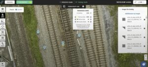
Manholes detected in a drone image over rails
Project Setting: Drone or Satellite Imagery?
Whether a proposed development sits in the middle of a crowded city or in a sparsely populated rural location, operating regulations pertaining to UAVs are becoming more complicated – especially in the United States. Numerous articles have been written about Line of Sight rules, but less focus has been placed on permitting requirements. Multiple jurisdictions either have already implemented drone permit rules or are considering them. This not only adds to the cost of flying UAVs but often inserts delays into a construction schedule.
“You can have three satellite collects occur over your project site in the time it might take to get a permit approved, as new legislation is enacted,” said Cassidy.
Invisible Environmental Conditions
For development projects of all sizes and locations, the condition of the environment must often be monitored before, during and afterwards. This is where multispectral and hyperspectral data becomes so valuable because subtle stress in vegetation and water bodies can be detected before they are visible to the naked eye. Currently, commercial satellites hold an advantage here since so many of them capture multispectral data in the infrared portion of the spectrum.
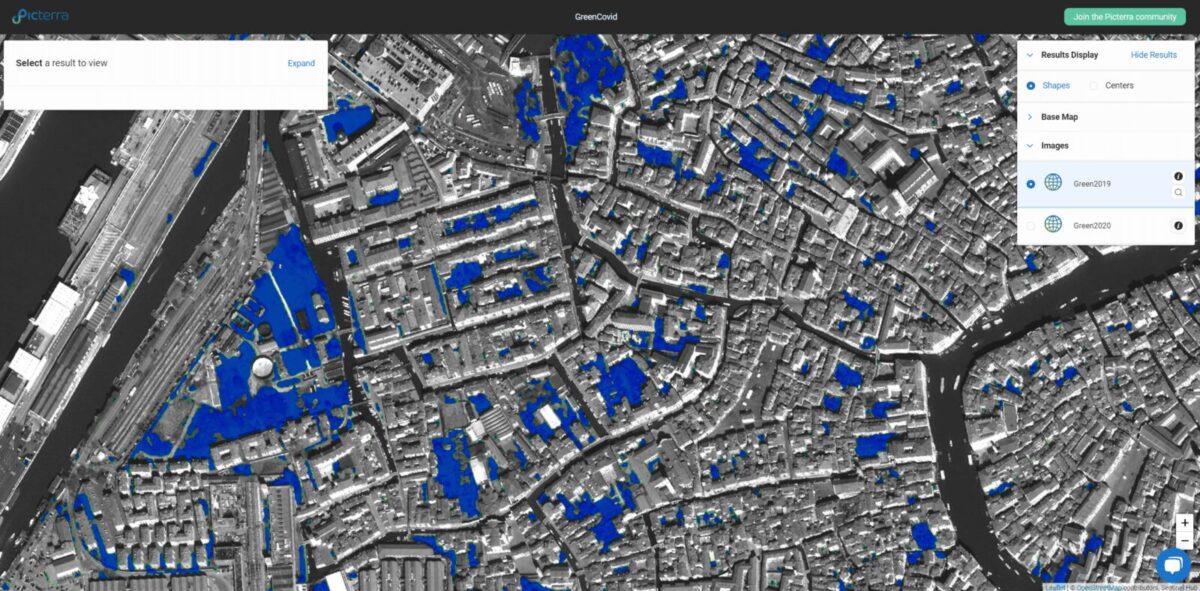
Vegetation detected in a satellite image over Venice, Italy.
This may change soon, however. Although not as common now and still relatively expensive, multi- and hyperspectral drone sensors are coming on strong and could soon overtake satellites in this application. The lingering challenge for drones, however, is correcting for atmospheric noise which impacts multispectral data more than visible data. Satellite sensors have corrected for much of this atmospheric distortion.
Data Processing Capabilities
Numerous construction companies have purchased a drone or bought satellite imagery only to find that creating a map or extracting critical information from the raw data requires two things they don’t have – adequate computing power and processing software. Drone and satellite image files contain enormous volumes of data that can’t be processed on many standard desktop computers. Fortunately, this problem is being neutralized by massive computing power now available in the cloud.
The software issue currently favors drone users. Powerful drone processing software packages, such as Pix4D and Virtual Surveyor, are affordable – and more importantly – can be learned by someone with little or no formal mapping experience. Satellite image software, on the other hand, remains expensive and complicated. But cloud services may be leveling the playing field here as well.
Software-as-a-Service (SaaS) business models are making extremely sophisticated satellite image exploitation functionality affordably available in the cloud, even with Artificial Intelligence capabilities. And for users who prefer not to deal with processing the data, Picterra is the perfect solution.
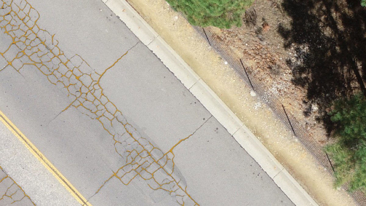
Road crack detector built on Picterra
The bottom line in choosing between satellite and UAV imagery on the construction site? Take all the variables into consideration, said Cassidy, and when in doubt rely on satellites for a macro view and drones for the micro details. Either way, one thing is certain – all types of remote sensing data play important roles in the AEC process. And the list of remote sensing data users in the AEC industry is growing.
“We are seeing remote construction monitoring information requested by architects, builders, bonding agencies, insurers, and even equipment rental companies,” said Cassidy. “Conflation of both UAV and satellite data processed and queried in a SaaS platform appeals to these firms.”
Harness the power of machine learning in both drone and satellite imagery
At Picterra, you’re free to analyze different types of imagery. The only limitation is the resolution, which is strongly linked with the size (seen from above) of objects that you want to detect. Construction sites can be detected even in low-resolution satellite imagery, however, if you need to detect objects, we generally consider that they need to have a width of at least 10px to be efficiently detected. To facilitate the decision, we’ve created a visual checklist that you can download for free below.
Drone or satellite? Which resolution do I need?