Picterra Tracer

Simplifying plot analysis for compliance, sustainability, and land monitoring

Validate and analyze land plots using satellite, drone, and aerial imagery. Simplify compliance with EUDR and other regulations, verify carbon credits, and streamline sustainability efforts – all within a modular, API-ready product.

About Picterra Tracer

Efficient plot validation and analysis
for today’s compliance and sustainability needs

Efficient plot validation and analysis for today’s compliance and sustainability needs

Picterra Tracer is a cutting-edge product designed to empower agriculture, commodities trading, forestry industries, and more by providing tools for validating, analyzing, and monitoring land plots. Whether ensuring compliance with the European Union Deforestation Regulation (EUDR) or verifying sustainability initiatives like carbon credits, Picterra Tracer works with satellite, drone, or aerial imagery, leveraging global or regional open-source layers so users can analyze plots accurately and confidently.

Watch on-demand

Simplify plot MRV for compliant supply chains & replace fragmented tools

See Picterra Tracer in action and learn more by watching our special GeoAI Bytes launch session.

Guide

Simplify plot analysis with Picterra Tracer

Download to learn more about Picterra Tracer

Ensure data quality

Rigorous data verification and correction

Picterra Tracer supports data ingestion from various formats – CSV, KML, GeoJSON – and geospatial imagery from satellite, drone, and aerial sources. Automatic data verification and geometry corrections ensure that the information you analyze is accurate, compliant, and ready for deeper insights.

Creation of plot boundaries

Automatically map plot boundaries

Automatically map plot boundaries using only location and area details. Following the crop pattern, Picterra Tracer can detect changes in canopy structure, roads, paths, and grasslands to guide the creation of accurate plot boundaries.

Advanced geospatial analysis

Turn data into accurate insights

With its robust analytical models, Picterra Tracer allows users to detect deforestation, assess land use changes, and verify carbon credits. These insights empower sustainability and compliance teams to make informed decisions and report accurately to regulatory bodies like the EUDR.

Modular API for tailored workflows

Integrate the product into your system, your way

Picterra Tracer is designed for easy integration into existing systems and workflows, with a modular API structure that aligns with a range of traceability and ERP ecosystems. Customers can start with the core analysis API and gradually expand to include features like data ingestion, visualization, and reporting, seamlessly integrating Picterra Tracer into their existing workflows and systems. With the modular API approach, customers can deploy Picterra Tracer’s functionalities selectively, creating customized solutions for traceability, compliance, and operational needs. This could include advanced deforestation analysis and additional API components like data ingestion, correction, and reporting, offering flexibility and value across traceability environments.

How It Works

Streamlined and efficient workflow

Plots data input

Import data from various sources and formats, including spreadsheets (.csv, .xls) and polygon files (KML, Shapefiles, geoJSON).

Verification and correction of plot data

Automate data ingestion, quality verification, and geometry correction and convert them into a GIS-readable file for further analysis.

Analysis and shipment verification

Perform deforestation risk analysis and other assessments on the data. Verified and corrected data is stored in a farm plots geospatial database.
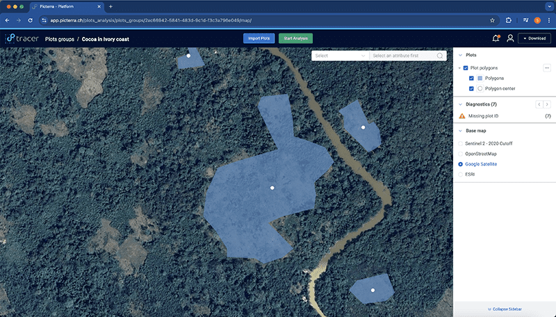
Data visualization

Interactively explore the results through visualization tools.

Integration via API

The modular API allows customers to integrate the product into traceability and ERP platforms, as well as the EUDR Information System.

Reporting and export

Export shipment verification and due diligence statements in EUDR-compliant formats.
Request a demo

Discover how Picterra Tracer can help you