Maxar is well known as a leading provider of Earth Observation (EO) imagery, partnering with innovative businesses and more than 50 governments to monitor global change. There’s a high chance that you’ve already seen their imagery on the nightly news or online publications.
With access to more Earth Observation images than ever before, companies across industries are realizing the strategic importance of this data, even ones that traditionally never saw a use case for satellite, drone, and aerial imagery.
With over 400 attendees, from 30 countries we were excited at the opportunity to be able to engage with domain experts who provide geospatial services and advisory to their clients and demonstrate the power of embedding our powerful machine learning capabilities into their applications.
From a personal perspective it was also lovely to visit the Portuguese Riviera and be able to network with new and existing clients!

One talk which really interested me was that given by Steve Yeager, Product Manager at Maxar. Steve talked about Maxar’s analysis-ready data (ARD) which consists of preprocessed time-series stacks of imagery that are aligned and produced at a set standard. This means that imagery can immediately be used in machine learning (ML) model development.
At Picterra we’re all about freeing up time for data science teams by automating tasks so they can concentrate on more value-added work. One feature of ARD is the vibrant color balancing, which better highlights features of interest in the imagery that may otherwise be hard to distinguish. This can really help during detector training when objects can be difficult to detect in certain image conditions, including low sun elevation angles, high off-nadir angles and extensive cloud cover.
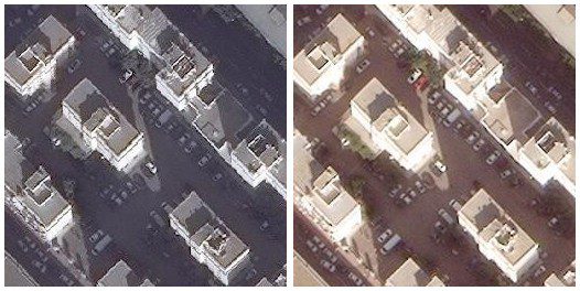
The WorldView-3 image on the left shows Algiers, Algeria, without ARD processing. The image on the right is the same image ordered through the ARD Order API.
I was sad not to have bumped into #GrantsHat whilst at the event, pictured below with Maxar’s WorldView-3 Earth Observation satellite. Grant’s use case of whale detection reminds me of a post my colleague Roger Fong authored on detecting seal and sea-lion populations!