
Customer stories
Civis. Forestry management & cycle monitoring at scale with geospatial AI.
Industry:
Forestry
Business type:
Geospatial AI service provider, specialized in the remote monitoring and management

About Civis
CIVIS is a geospatial AI service provider that specializes in the remote monitoring and management of forestry. They work in a number of verticals applying AI solutions to spatial data taken with a variety of sensors both airborne and terrestrial.
In particular, CIVIS works with forestry companies that are managing large areas of land and supports them with an end-to-end solution for monitoring the full forestry lifecycle. This includes during harvest, soil preparation, and plantation.


Challenge
CIVIS is currently analyzing over 50,000 hectares of forest for some of the largest forestry groups in Latin America.
With such a large area to manage the main challenge for CIVIS was how to scale their analysis and provide actionable information to their clients in a timely manner. The information gathered by CIVIS is used by their customers for future work planning, coordination with external contractors, and verification of task completion and standards compliance. These are all required within strict and well-defined timescales.
Detections undertaken by teams of people manually inspecting the fields is a slow and often-times inaccurate process. The performance rate of such a process is typically one hectare per person per day, with mistakes occurring due to distraction and tiredness. This further imposed a need for an additional team for quality control. Therefore, even with a team of 100 people, this would take over a year and a half of continuous work for 50,000 hectares!
The challenge we had was mainly related to the fact that we had to deliver time-sensitive information. We tried different solutions including getting the detections manually, and using people – the rate was about 1 ha per person per day. So you would need an army to carry out this task.
Alfredo Aramayo, CEO at Civis
Once CIVIS started to collect imagery using drones a second challenge emerged. Again due to the scale of the analysis area and the high-resolution imagery being captured, they started to accumulate massive amounts of data that needed to be processed and analyzed in an efficient manner.

Solution
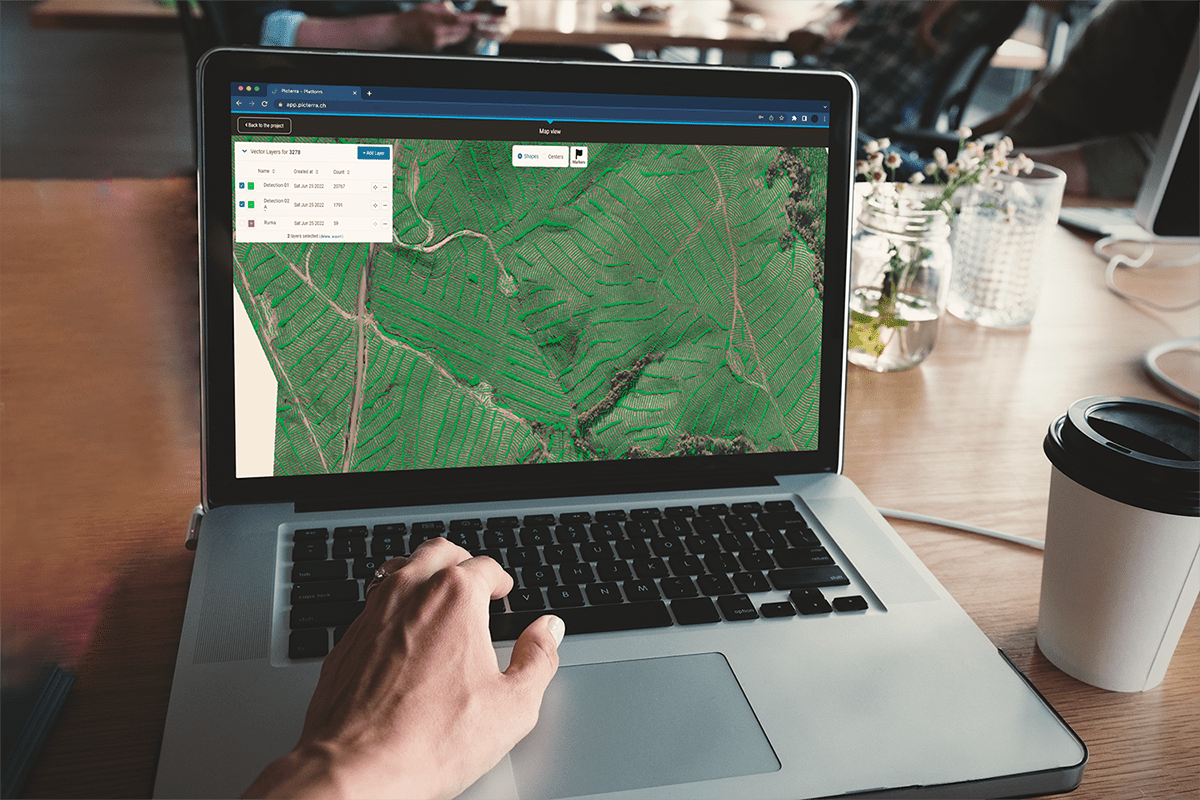
CIVIS provides an end-to-end forestry cycle monitoring solution – it starts with flying UAVs over the areas of interest (AOI) and collecting imagery at high levels of GSD. The imagery is then processed into orthophotography and uploaded to the Picterra platform. Within the platform, the team is building and training machine learning models to detect a range of visible features of interest.
Once the models are executed, the team verifies if any clean-up is needed using a set of in-house developed geospatial tools to eventually provide customers with actionable information through web-based platforms and mobile apps.
Civis has also developed a mobile application that allows contractors working for their customers to report on their progress/work on a daily basis (mobile mapping app).
Activities
Picterra is then used to analyze and validate the reported progress, helping to identify non-compliance or delays and flag them, improve productivity, guide contractors, and even advise payroll. The monitored activities/jobs are around i.e. :


Results
CIVIS has a small team of 15 geospatial professionals /data scientists, experts in ArcGIS, QGIS and similar GIS tools who build and train the models in Picterra, run the detections and then verify the quality.
This is 15+ Terabyte of imagery in a single folder for a single user.

Thanks to Picterra CIVIS team can detect objects on ALL of it by clicking on a SINGLE button.
Using the platform also allows automation of the quality control/cleaning of false positives and even though there is still a need for a team of specialists for data verification and clean up it can be done with less people & faster.


Why Picterra
Quickly and efficiently scale
Picterra allows CIVIS to quickly and efficiently scale – at the beginning of the cooperation in the initial POC project CIVIS was running detections at 10 hectares and now the coverage is 50,000 hectares every 6 months, This would not be possible without Picterra, and the scalability that the platform offers.
Leveraging machine learning
Leveraging machine learning and the Picterra platform allowed CIVIS to step away from inefficient manual and labor-intensive processes (sending people into the field to collect information over large areas) and immediately scale the service efficiency, quality, and coverage.
Process automation
The whole process has been automated.
Achieve and deliver fast result
Thanks to Picterra, the CIVIS team was able to build and train detectors autonomously and achieve and deliver results fast. The day after they started using Picterra they could already deliver results.
Impressive speed and accuracy
Picterra’s speed and accuracy are impressive, results are achieved very quickly and in an accurate way. It saves a lot also in terms of headcount.
Fun fact
Once CIVIS lost one UAV and used Picterra to find it, they searched for a specific color that should have differentiated the lost equipment from the surrounding greenery and were able to locate part of the crashed equipment. This info proved useful with the insurance claim and establishing the cause of the crash.
Picterra is a solution out of the box – we were able to deliver the results the day after we started using the platform and have grown from an initial POC project over 10 hectares, when we tested the platform, to monitoring 50,000 hectares every 6 months.
It is a matter of accuracy and speed – with Picterra we can have results very quickly and in an accurate way. Using Picterra also saves a lot in terms of headcount required. The challenge we had was mainly related to the fact that we had to deliver time sensitive information. We tried different solutions including getting the detections manually, using people – the rate was about 1ha / person per day. So you would need an army to carry out this task.Alfredo Aramayo, CEO at Civis
Start using Picterra
Discover our flexible plans that scale with your business
Our Approach
Vivamus porttitor scelerisque tellus, in ultrices metus. In lacus lectus, porta vel vulputate ac, vehicula vitae nibh. Duis ipsum dui, auctor nec turpis eu, posuere fermentum augue. Praesent tellus justo, aliquam sit amet facilisis vel, feugiat nec felis. In ultricies iaculis ipsum vitae placerat. Morbi malesuada, felis eget aliquam hendrerit, felis ex tincidunt mi, gravida facilisis leo nisi nec tellus. Aenean lobortis blandit turpis, sed sollicitudin metus auctor ac. Fusce lacinia interdum metus. Pellentesque et quam nisi. Sed fringilla gravida lorem, id rhoncus justo egestas sed.
Curabitur pharetra commodo enim, id cursus neque dapibus sed. Curabitur pellentesque faucibus purus, non finibus turpis pretium non. Donec tempor lectus sed tincidunt sodales. Proin lobortis, nibh eget tincidunt placerat, elit sem luctus est, sed cursus enim mauris vel odio.
The Results
Morbi malesuada, felis eget aliquam hendrerit, felis ex tincidunt mi, gravida facilisis leo nisi nec tellus. Aenean lobortis blandit turpis, sed sollicitudin metus auctor ac. Fusce lacinia interdum metus. Pellentesque et quam nisi. Sed fringilla gravida lorem, id rhoncus justo egestas sed.
Curabitur pharetra commodo enim, id cursus neque dapibus sed. Curabitur pellentesque faucibus purus, non finibus turpis pretium non. Donec tempor lectus sed tincidunt sodales. Proin lobortis, nibh eget tincidunt placerat, elit sem luctus est, sed cursus enim mauris vel odio.