


Industry:
ESG
Business type:
Global environmental organization
Industry:
ESG
Business type:
Global environmental organization
In the vast expanse of the world’s oceans, a delicate balance of life and biodiversity thrives beneath the surface. Among the most critical and vibrant of these underwater ecosystems are coral reefs. Despite occupying a mere 1% of the ocean floor, these “rainforests of the sea” provide a habitat for 25% of all marine species and multiple ecosystem services that promote human well-being. However, these vital ecosystems are under threat, facing challenges from climate change, overfishing, disease, and human activity.
Enter Dr. Steve Schill, Lead Scientist at The Nature Conservancy (TNC), who has dedicated the past two decades of his career to the preservation and restoration of these invaluable ecosystems. Working with TNC’s Caribbean Division, Steve collaborates with governments across 17 countries and territories in the insular Caribbean, developing new science data and tools that assist them in achieving their conservation and sustainable development goals.
TNC’s work is multi-faceted, focusing on expanding marine protection, improving management effectiveness, and modeling benthic habitats to monitor their health. The organization makes strategic recommendations on the best areas to protect, considering not only the biological aspects, but also the human benefits. These benefits range from fisheries production and coastal protection to recreation and tourism.
One of the key strategies in TNC’s conservation efforts is the focus on protection and restoration of coral reefs as the organization is committed to monitoring and improving the mapping of these reefs. They also keep a close eye on the health and status of the reefs, observing how they change over time.
To aid in the recovery of corals, TNC has established coral innovation hubs, such as the one in the US Virgin Islands. Here, they grow corals in controlled environments before outplanting them on reef tracks. This innovative approach is part of their efforts to assist nature in the recovery and restoration of these vital habitats.
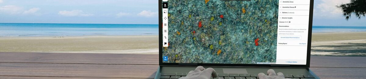
Monitoring the success of these restoration efforts is a complex task. TNC employs techniques such as underwater photogrammetry (i.e. Structure from Motion) where they take underwater stereo photos and recreate the reef monitoring site in 3D. However, to cover larger areas and identify changes in corals over square kilometers, they have turned to drone technology.
Picterra allows TNC to identify and map the coral after collecting drone data. It enables them to quantify the success of their restoration efforts by looking at the increase of coral cover across these reef tracks. This method is being implemented in several locations, including The Bahamas, Grenada, and the US Virgin Islands.
Given the vast amount of data we collect, we often find ourselves limited in how much we can actually process. We've been searching for ways to increase our efficiency, and this is where Picterra comes into play. Their technology has been instrumental in helping us manage and make sense of our data more effectively.
Dr. Steve Schill, Lead Scientist at The Nature Conservancy, Caribbean Division
The team is using a combination of drone imagery and SkySat satellite imagery to map habitats at different scales. This two-pronged approach allows them to conduct an initial coral survey with SkySat for a broader understanding, followed by a more detailed exploration with drones. The goal is to maximize the coverage of the area with the satellite, then use the drone in strategic areas to collect more accurate and detailed data.
As the volume of data collected grows, so too does the breadth and depth of TNC’s projects, reflecting the expansion of their objectives. However, the increase in data volume also presents internal challenges in terms of data handling and management. During a 10-day field trip to Tahiti in April, they collected 1-cm imagery covering a thousand hectares. Processing this vast amount of data is a challenge in itself, not to mention the task of extracting valuable information from it.
An important part of data capture is making sure the camera parameters are set to capture crisp images without any blur. This is particularly challenging as they generally fly at about 65-meter elevation altitude, and the drone moves very fast.
The time of day to execute the flights is also critical. They have to fly early in the morning or late in the afternoon when the sun is not very high on the horizon. If the sun’s angle gets too high, it creates glare on the water, making it difficult to see through the water column. The team has to deal with minimal light and adjust the ISO settings accordingly to capture the best imagery without degrading the image quality.
After capturing the data via drones, the team brings back an external drive full of hundreds of gigabytes of data. Before the data reaches the point where models can be built to analyze the corals, there are additional post-processing steps that are involved. The geographic tag for each of the thousands of photos collected are corrected to a high level of geometric accuracy (+/- 2-3 cm), using a GNSS base station that tracks the GPS error during each of the flights.
The next critical step is color correction using Lightroom to enhance the images through the water column, which makes the corals stand out and easier to map. Once the images are enhanced and balanced in Lightroom, they are ready to be turned into mosaics.
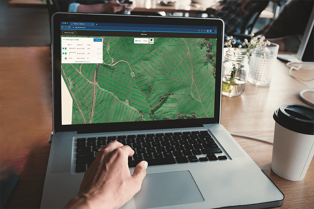
TNC works with DroneDeploy to upload the images and create orthomosaics and digital surface models. At this point, the products are ready for information extraction.
In the quest to protect and restore coral reefs, the ability to accurately identify and track different coral species is paramount. TNC has been collaborating with Dr. George Raber, from the University of Southern Mississippi, who does research on machine learning methods of identifying coral. Working together with Picterra, they build detectors and train models that identify different species of coral. TNC’s partnership with Picterra has two approaches: having Picterra process the data and present the results, or being trained on the platform to do the work themselves. This partnership has already begun to enhance their capabilities and improve the efficiency of their work.
To be able to quantify how the reef tract is changing at fine scales is something we haven't been able to do before until we started collecting drone data and using Picterra
Steve Schill, Lead Scientist at The Nature Conservancy, Caribbean Division
The initial detector was developed using imagery captured by a Wingtra drone and leveraging hand digitized labels or coral species. With the help of Steve and his team’s knowledge of the coral in question, the next step was to verify these labels and fill in any missing corals within the training and accuracy areas. Given that the coral is underwater and at different depths, it was crucial to capture representative coral in varying sizes, conditions, and depths to ensure the model wasn’t just being trained on those at the shallowest points.
The second detector, created by TNC, expanded on the first to include a total of four different types of coral within the same initial Area of Interest (AOI). These coral genera include Orbicella, Millapora, Diploria, and Acropora. This detector utilizes the ability to distinguish multiple classes within the same detector.
TNC is using Picterra to develop libraries for a wide range of coral genera and species. Elkhorn coral (Acropora Palmata), is one of the coral species they are restoring, and is of particular interest due to its rarity and ability to grow fast. However, they are also building libraries for other genera like the Diploria (brain coral) and Orbicella, a hard, stony coral that grows quite large. These species are being affected by a disease called stony coral tissue loss disease, increasing the need to track these corals.
The different patterns and colors of these corals are what they want to automatically recognize. If they can build a species-level detection system, they can more effectively track how each of these corals are changing. They also want to monitor the stresses the corals are facing, such as bleaching or disease, to better understand and improve their restoration efforts.
For Steve and TNC, tracking Acropora Palmata has been an enlightening journey filled with valuable insights and growth. The team has been experimenting with different deep-learning models and looking at accuracy based on different data collection parameters, such as different times of day, camera settings, and atmospheric conditions. They are identifying where their accuracy is going to be the highest and developing standards for data collection and processing techniques to share with other coral restoration partners in order to build coral monitoring capacity.
The integration of drone technology and machine learning tools like Picterra into TNC’s workflow has brought about significant benefits. Picterra’s involvement has brought a new dimension to the project, offering a fresh perspective and innovative solutions to the challenges faced. Picterra’s expertise in dealing with complex data sets and their ability to provide detailed analysis has proven invaluable.
This collaboration is not only benefiting the current project in areas like the Caribbean and French Polynesia, but is also setting a precedent for future coral conservation efforts worldwide. For the first time, they can quantify at the colony level how reef tracts are changing over much larger areas. This was something that was previously very challenging to do in a shallow, high wave energy environment just a few years ago. Now, TNC is able to monitor reefs across long stretches of reef tracts, process the data, and be able to count species and measure live coral cover.
Looking ahead, Steve Schill and his team have ambitious plans for the future. They want to expand their capabilities and improve the accuracy of mapping corals beyond the current two to three-meter depth limit that drones can provide. They are also interested in exploring the relationship between drone and satellite imagery. While drones are excellent platforms for monitoring at the local scale, if they want to map all the coral colonies across an island nation, high resolution satellite imagery is a more practical option. The challenge lies in making the connection between what they can do with drone imagery and how that ties in with satellite imagery.
The field of machine learning and feature identification is evolving rapidly, and I see it having more and more applications in our work. Whether it's monitoring coral reefs, tracking agroforestry practices to prevent soil erosion, or identifying tree species, Picterra has been a game-changer. The possibilities with Picterra are vast and we're excited about the many ways it can aid our conservation efforts.
Steve Schill, Lead Scientist at The Nature Conservancy, Caribbean Division
Beyond expanding their technological capabilities, Steve is particularly excited about empowering local communities to take charge of their own coral conservation efforts. He has been actively involved in training partners and envisions a future where countries can fly drones, process the data, and use the libraries they’ve developed to do their own mapping.
TNC is providing support and guidance to countries in their efforts to safeguard marine environments. They are advising governments on identifying suitable areas for protection, encompassing various habitats beyond coral reefs, such as mangroves and seagrass. They aim for some of these marine protected areas to be no-take zones, where no fishing or extractive activities are allowed. Such areas serve as fish banks, contributing to the sustainability of marine resources.
These coral restoration projects are a shining example of how technology can aid in our understanding and preservation of the natural world. By harnessing the power of drone and satellite imagery, and deep learning with Picterra, TNC is not only restoring the coral reefs across the Caribbean and French Polynesia, but also paving the way for future conservation efforts worldwide.
Through the combined efforts of dedicated scientists, innovative organizations like TNC, and powerful tools like Picterra, hope exists for the future of our world’s coral reefs. Their work serves as a reminder of the intricate link between nature and people, and the importance of preserving these invaluable ecosystems for generations to come.
Whether it's monitoring coral reefs, tracking agroforestry practices to prevent soil erosion, or identifying tree species, the possibilities with Picterra are vast and we're excited about the many ways it can aid our conservation effort
Steve Schill, Lead Scientist at The Nature Conservancy, Caribbean Division
Vivamus porttitor scelerisque tellus, in ultrices metus. In lacus lectus, porta vel vulputate ac, vehicula vitae nibh. Duis ipsum dui, auctor nec turpis eu, posuere fermentum augue. Praesent tellus justo, aliquam sit amet facilisis vel, feugiat nec felis. In ultricies iaculis ipsum vitae placerat. Morbi malesuada, felis eget aliquam hendrerit, felis ex tincidunt mi, gravida facilisis leo nisi nec tellus. Aenean lobortis blandit turpis, sed sollicitudin metus auctor ac. Fusce lacinia interdum metus. Pellentesque et quam nisi. Sed fringilla gravida lorem, id rhoncus justo egestas sed.
Curabitur pharetra commodo enim, id cursus neque dapibus sed. Curabitur pellentesque faucibus purus, non finibus turpis pretium non. Donec tempor lectus sed tincidunt sodales. Proin lobortis, nibh eget tincidunt placerat, elit sem luctus est, sed cursus enim mauris vel odio.
Morbi malesuada, felis eget aliquam hendrerit, felis ex tincidunt mi, gravida facilisis leo nisi nec tellus. Aenean lobortis blandit turpis, sed sollicitudin metus auctor ac. Fusce lacinia interdum metus. Pellentesque et quam nisi. Sed fringilla gravida lorem, id rhoncus justo egestas sed.
Curabitur pharetra commodo enim, id cursus neque dapibus sed. Curabitur pellentesque faucibus purus, non finibus turpis pretium non. Donec tempor lectus sed tincidunt sodales. Proin lobortis, nibh eget tincidunt placerat, elit sem luctus est, sed cursus enim mauris vel odio.

