/

January 17, 2022

What is geospatial intelligence, exactly?

geospatial intelligence

The whole industry is guilty of throwing around the expression “geospatial intelligence”. But what does it really mean? How does it differ from Geographic Information System (GIS)? We’ve put together a quick guide to shed some light on this emerging concept within the geospatial world.

The humble origins of geospatial intelligence

It’s a common misconception that geospatial intelligence is just about maps and geographic information. Geospatial intelligence, or GEOINT for short, is actually the fusion of imagery and geography, which can be used to help solve a wide range of problems. In fact, it has a very long history. In its most basic form, geospatial intelligence has been around since humans first learned to tell stories about their surroundings. The storyteller drew an image on a cave wall using charcoal or other natural pigments, and that image became part of the story. Geospatial intelligence was born with this human tendency to communicate about our surroundings through drawings and paintings.

With the advent of photography and film technology, it became possible for images to be captured on stable media and preserved for later use. For example, the Americans used “Keyhole” spy satellites to capture photographic surveillance of foreign powers in the 60s and 70s. (Fun fact: they dropped film negatives using a parachute and captured them in the air by a plane to avoid losing them on foreign lands.)
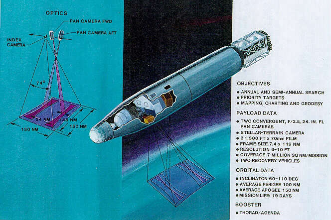
Corona satellite image

Source: Wikipedia

Advanced by digital technology, the expression takes root

It wasn’t until the creation of digital technology that geospatial intelligence really came into its own. Digital cameras on satellites, vehicles, and drones are capable of collecting enormous amounts of data in seconds, which can be stored in databases and harnessed for future queries or analyses. Imagery processing software can turn raw pixels into meaningful information: crop patterns on farmland; vehicle traffic on a highway; changes in vegetation growth over time; shipping activity at a port; or even street-level views of popular tourist destinations.

But the term itself actually has its roots in the US military and intelligence communities. The term gained popularity in 2004 when the National Imagery and Mapping Agency of the US Department of Defense was renamed the National Geospatial-Intelligence Agency (NGA).

A September 2006 memo from NGA defines geospatial intelligence as: 

“The exploitation and analysis of imagery and geospatial information to describe, assess, and visually depict physical features and geographically referenced activities on the Earth. GEOINT consists of imagery, imagery intelligence, and geospatial information.” 

Today, the expression is used beyond the military sectors and is widely adopted by the research community and commercial organizations (like Picterra). 

GIS vs. geospatial intelligence: what’s the difference?

GIS refers to geographic information stored in layers and integrated with geographic software programs so that spatial information can be created, stored, manipulated, analyzed, and visualized. Such information includes any data source that has a location attached to it (e.g. zip codes, addresses, coordinates, etc.). It can be derived from many sources including GPS sensors, satellite and drone imagery, geotagging, and so on.

GEOINT should be considered a subcategory of GIS. It is a field for using geospatial data in combination with other analyses to improve and reduce uncertainty in critical decision-making. As the European Union’s Satellite Centers (“SatCen”) neatly puts it

“GEOINT combines several disciplines such as mapping, charting, imagery analysis, and imagery intelligence.”

Geospatial intelligence reveals patterns and relationships that would have been impossible to spot if the data remained as a raw set of locations. 

How does this expression help us?

With the growing demand for accurate geographically-based information, geospatial intelligence captures two emerging trends:

  1. Incorporating satellite and aerial imagery into a business’ data strategy and considering it as ubiquitous as any other data source; and
  2. Turning data into insights by using new, powerful computing techniques, such as machine learning and high-performance computing, to analyze it at scale

In fact, geospatial data is just like any other data source. It needs to be collected responsibly (with minimal impact on humans, animals, and the surrounding environment) and presented in an understandable way. By using geospatial intelligence, organizations can enrich their decision-making by measuring the impact of past decisions and understanding why something went right (or wrong). Here are three industry-specific examples:

What once began as a military concept is becoming mainstream in more and more industries. It all starts with giving decision-makers an easy way to interact with data so they can explore relevant geospatial intelligence applications for their business.

Want to learn more?

sign up to our newsletter