Search Results for: ESG – Page 2

Picterra resource hub: Webinars, whitepapers, & more

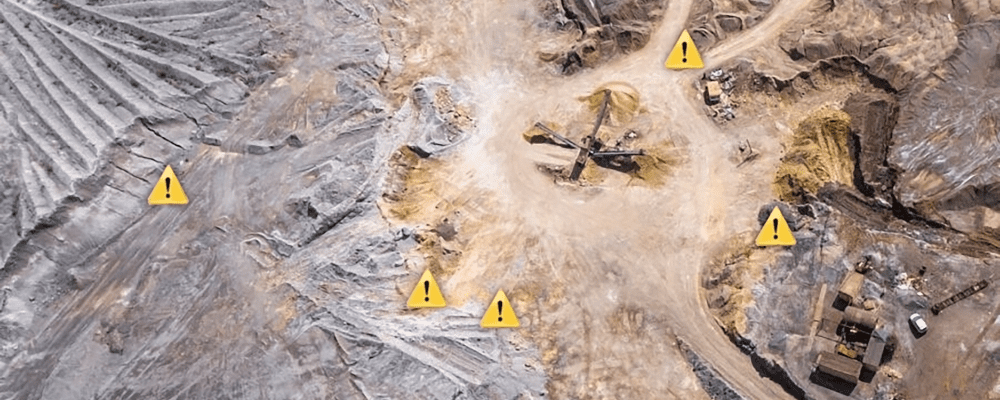
Resource hub AlleGuides & eBooksFactsheetsPodcastsVideosWebinarsWhitepapers Environmental benefits of remote sensing and geoAI for artisanal and small-scale mining Featured, Webinars Learn more What is change detection? eGuides & eBooks Environmental benefits of remote sensing and geoAI for artisanal and small-scale mining Featured, Webinars How to revolutionize safety in mining operations using geospatial data & AI Videos…

View detals
Blog

News & blogs AllCustomersData scienceEventsIndustriesNews & PressPlatform Mining sustainability: using geospatial data to reduce environmental footprint & mitigate risks Data science, IndustriesMay 25, 2023 5 benefits of real-time monitoring & intelligence in mining operations Data science, IndustriesMay 18, 2023 Why accuracy areas are vital to building successful ML projects PlatformMay 3, 2023 Reducing mining operation…

View detals
Picterra customer stories: See why enterprises trust us

Customer stories See why leading enterprises across the world choose Picterra Revolutionizing coral mapping: The Nature Conservancy’s collaboration with Picterra The Nature Conservancy & Picterra collaborate in conserving coral reefs by leveraging drones & AI to efficiently identify & monitor different coral types. Read customer story Monitoring reefs changes and measuring live coral cover across…

View detals
Picterra's geospatial machine learning platform is used across a broad range of industry applications.
Solutions

Explore how geospatial machine learning drives innovation in your industry Collecting, processing, and analyzing geospatial data is creating powerful new applications that are reshaping how entire industries operate and transforming our relationship with Earth. Professionals across industries use Picterra’s geospatial machine learning platform to drive this change at scale. Mining & quarries Learn more FMCG…

View detals
SatSummit22
Geospatial data for the greater good: SatSummit 2022 highlights

SatSummit is an event that gathers leaders in the satellite industry and experts in global development for 2 days of presentations and in-depth conversations on solving the world’s most critical development challenges with satellite data. From climate change to population growth to natural resource availability, earth observation data offers insights into today’s biggest global issues. This…

View detals
Waldstolz
How Waldstolz is combatting bark beetles infestations with satellite imagery and geospatial ML

German-founded Waldstolz has launched a war on bark beetles using state-of-the-art forest monitoring solution combining Planet’s satellite imagery and geospatial machine learning. Using Picterra’s platform, Waldstolz has built detectors that recognize inklings of infestations in the images that would be impossible for the human eye to spot, allowing for detection of early outbreaks before the infestations spread, which in turn prevents major spruce loss and salvage timber value.

View detals
Picterra co-founders Pierrick Poulenas & Frank de Morsier
Picterra raises $6.5M to accelerate its mission of democratizing geospatial mapping

Lausanne, Switzerland, 26 April, 2022 – Picterra, the leading provider of geospatial machine learning software, today announced the closing of a $6.5M investment. Led by venture capital firm VI Partners, with participation from ACE & Company, the investment will enable Picterra to pursue its mission of democratizing access to Earth observation imagery and geospatial ML.…

View detals
mining lifecycle
A guide to geospatial AI during the mine lifecycle

There are a comprehensive set of rules and regulations that govern the mining exploration industry. With the rising importance of Environmental, Social, Governance (ESG) standards, mine operators are also required to pay closer attention to their impact on surrounding communities and ecosystems. Moreover, to attract sustainable capital, they need to provide impact investors with auditable…

View detals