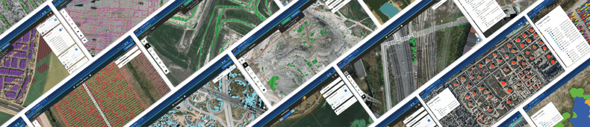
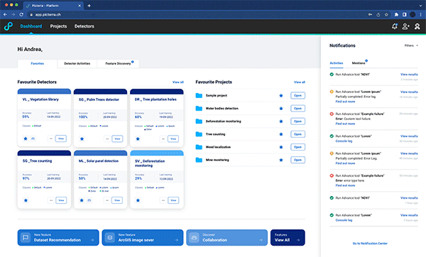
Picterra Platform
Turn geospatial imagery data into powerful deep learning models
Detect objects, patterns, and change faster than ever before by managing the entire geospatial ML pipeline with our cloud-native platform.
why picterra
Experience the future of machine learning with Picterra and revolutionize your data-driven workflows
By leveraging the Picterra platform, you can unlock unprecedented speed, optimize data utilization, scale your analyses to new heights, and enjoy substantial cost savings.
95% 95% 95%
faster
Leap into the future of unparalleled efficiency with Picterra. Our platform revolutionizes the production of scalable machine learning models, transforming months into days. Streamline your workflow, save valuable time, and achieve unmatched speed.
99% 99% 99%
less training data
Maximize your data’s potential with our smart annotation toolkit, intuitive UI, and advanced data curation tools. Train your custom models directly on your data with Picterra, reducing training data requirements by an astounding 99% while boosting accuracy and performance.
50x 50x 50x
larger scale
Embrace the vastness of geospatial analysis with ease. With Picterra, run country-scale analysis in a matter of hours, at the click of a button. Our fully automated model production deployment handles massive datasets effortlessly, enabling comprehensive insights at an unprecedented scale.
90% 90% 90%
less expensive
Unleash the power of deep learning models without the hefty price tag. Picterra provides a cost-effective solution that significantly cuts your expenses, eliminating the need for expensive data science services. Harness cutting-edge technology across your organization in a wallet-friendly way.
interactive demos
Try our interactive tours

Get a sneak peek of Picterra platform and explore intuitive interface, models creation, training and production environment and more.
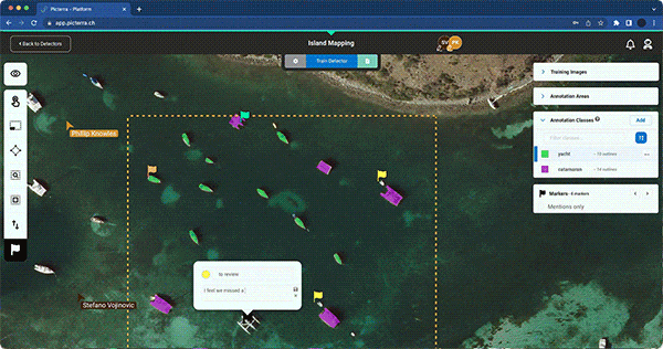
Discover real-time collaboration on the Picterra platform & see first hand how you can combine deep learning expertise with operational know-how for unparalleled results.
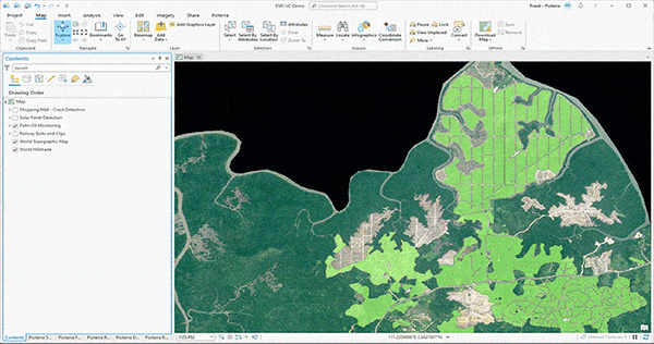
Explore how Picterra and ArcGIS Pro work together, elevating your geospatial workflows with enhanced efficiency.
Key features
Lead the way with powerful platform features & capabilities
By combining a no-code approach, a user-friendly interface, seamless scalability and cutting – edge machine learning technology, Picterra accelerates the development of full-scale ML projects.
Menu
Object detection
Organize, prepare, & store your data
- Analyze and consolidate your EO imagery libraries from satellite, drone, and aerial sources in one platform.
- Process optical RGB and multispectral imagery including false color, thermal, SAR, NIR, and height maps.
- Upload imagery directly via the web interface or import from a local server, cloud storage, or ArcGIS Image, WMS and XYZ servers.
- Enrich data to strengthen models with advanced GIS pre-processing and post-processing tools in just a few clicks.
Object detection
Autonomously create & deploy ML models at scale
With Picterra you can create a scalable system to operate geospatial machine learning models in production and continuously develop them. Create deep learning models quickly and efficiently with help of smart annotation toolkit and user friendly UI. Leverage state of the art machine learning models architecture with the ability to customize the algorithms to your specific needs and benefit from best-in-class support from our team of experts.
Lead the way with powerful platform features and capabilities:
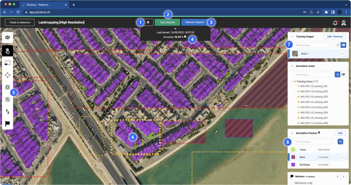
Access to advanced detector settings
Accelerate model creation and production deployment by relying on a thoroughly tested and optimized standard detector settings.
Experiment with advanced model settings such as backbone model, training tile size, or background sampling ratio.
Auto-scaling on cloud infrastructure
Custom deep learning architecture optimized for geospatial imagery.
Auto-scaling infrastructure with adjustable capacity to ensure predictable and efficient processing. Fast prototyping and large scale inference.
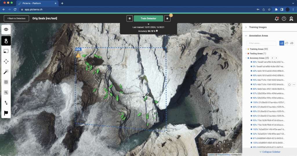
Detector training report
Get insights into how your model is performing, understand accuracy across multiple classes and analyze your model behavior.
Detector accuracy score
Assess performance of your model.
Compute accuracy score with the help of representative accuracy areas and example regions your model will run on when deployed at scale.
Smart annotation toolkit & drawing tools
Intuitive model training toolbar that helps you structure all the steps required to create, train and deploy your custom model.
Model development & training UI
Easy to use web UI for no-code ML model training
Import existing data using the API and advanced detector settings.
Run your model on an entire image library with one click thanks to fully automated model production deployment.
Optimized detection areas
Draw or upload existing detection areas.
Ensure fast and accurate detectors by customizing the shape and size of detection areas. Useful when monitoring linear objects (e.g., railways, roads, rivers) or AOI scattered within the imagery.
Single or multi-class detector workflows
Assign up to 10 classes in a single detector (instance & semantic segmentation).
Achieve efficient and faster workflows when working with sub-classification or sub-categorization of objects within a specific class.
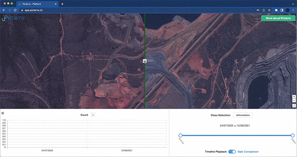
Change detection
Navigate change detection challenges with precision and efficiency
- Explore different ways to solve your change detection challenges in Picterra – from detecting subtle changes in objects movements or appearance, land patterns shifts to exploring comprehensive transformations across terrains.
- Benefit from specialized change detection models, streamlined annotations and efficient algorithm training, as well as meticulous change analysis.
Blog
Picterra pioneers revolutionary change detection technology for geospatial imagery
Read the article 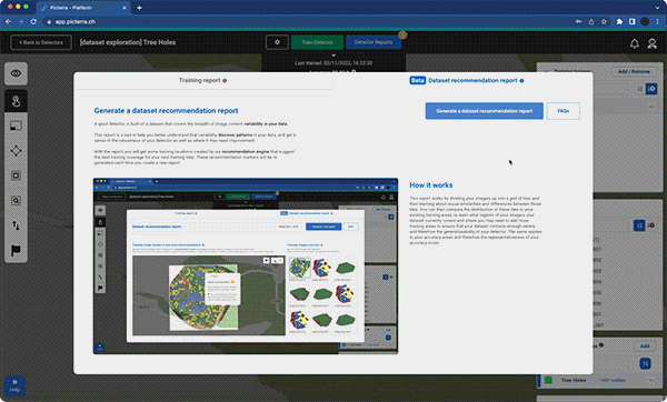
Detector insights
Boost model accuracy & quality with powerful detector insights tools
Explore your data variability with a Dataset Recommendation report to reveal visual patterns in the dataset and automatically pinpoint areas for additional annotation to improve model training coverage
Seamlessly iterate & enhance your model performance with help of powerful detector insights tools – localized results warnings, accuracy scoring, model confidence maps or improved area of interest (AOI) management
Blog
Boost geoAI model performance: Picterra's new tools for improved accuracy & insights
Read the article 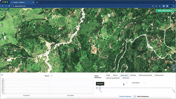
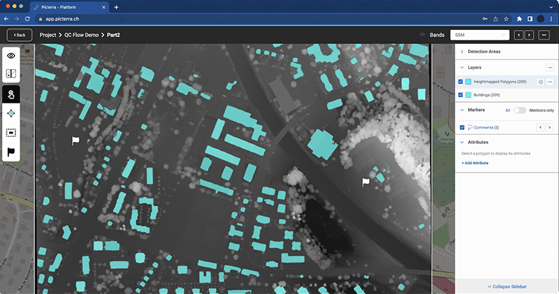
Results
Present compelling results & visualize your findings
Extract valuable insights from the detections delivered by your models and visualize them as interactive web or change monitoring reports.
Simplify the process of reviewing, editing, and refining your detection results with streamlined quality control
Ensure reports are easily accessible to all stakeholders within or outside an organization by sharing a link which does not require a Picterra account to view.


Blog
Manage geoAI model insights & results more effectively with Picterra platform updates
Read the article 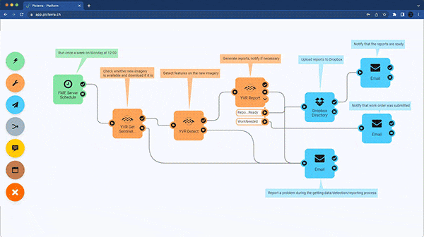
Integrations
Take your work further
- Use the REST or Python API and integrate Picterra capabilities directly into your applications to seamlessly extend and enrich your workflows.
- Facilitate faster execution and automation of a range of tasks and run them at scale, e.g., upload georeferenced images (from local or remote servers) to Picterra, import object annotations or detection areas or train detectors.
- Develop solutions and customized dashboards that leverage the power of Picterra’s machine learning.
- Integrate Picterra into your own solutions
Interactive tour
Explore how Picterra and ArcGIS Pro work together in our interactive tour
Take the tour Toolbox
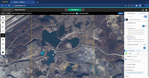
Magic wand
Expedite the annotation process through the aid of our AI magic wand, powered by Meta AI’s Segment Anything Model (SAM). This innovation enables one-click annotation of land patterns or objects, significantly simplifying the annotation work.
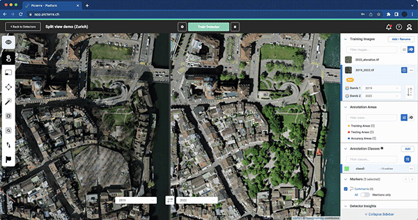
Split screen
Platform feature that splits your imagery into two halves. One side presents the “before” image, while the other showcases the “after” image (with customizable order). Annotations on one side seamlessly populate on both images, streamlining your workflow.
|
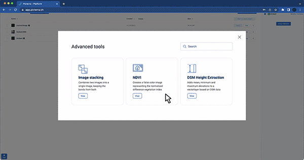
Streamline and simplify geospatial workflows with access to the most common GIS tools in just a few clicks and build more accurate models by enriching them with diverse data.
|
Collaboration
Discover real-time collaboration on the Picterra platform & see first hand how you can combine deep learning expertise with operational know-how for unparalleled results.
|